Why are so many megafauna fossils found in Lancefield, Victoria?
A data visualisation story for RMIT MATH2404 By Andrew Ballard — s9205210
The viewer is invited to move the map at any time to explore further afield:
- move by clicking & dragging
- zoom in/out using your scroll wheel
- and rotate/change 3D angle with a control-drag.
You will be guided through the story as you scroll this text panel to continue to narrative.
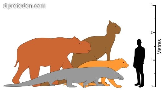
1) What is/was megafauna?
Megafauna (literally 'large animals') roamed across Australia from as far back as 2.5 million years ago. Species ranged from giant reptiles to oversized marsupials.
Their extinction happened as recently as 40,000 years ago. While some explanations point to the overlap of human settlement within Australia, the consensus is firmly on climate change: the extinction timeline correlates with start of the most recent ice age - the marker which ended the first half of the Quaternary period (the Pleistocene) and ushered in the latter half, the Holocene.
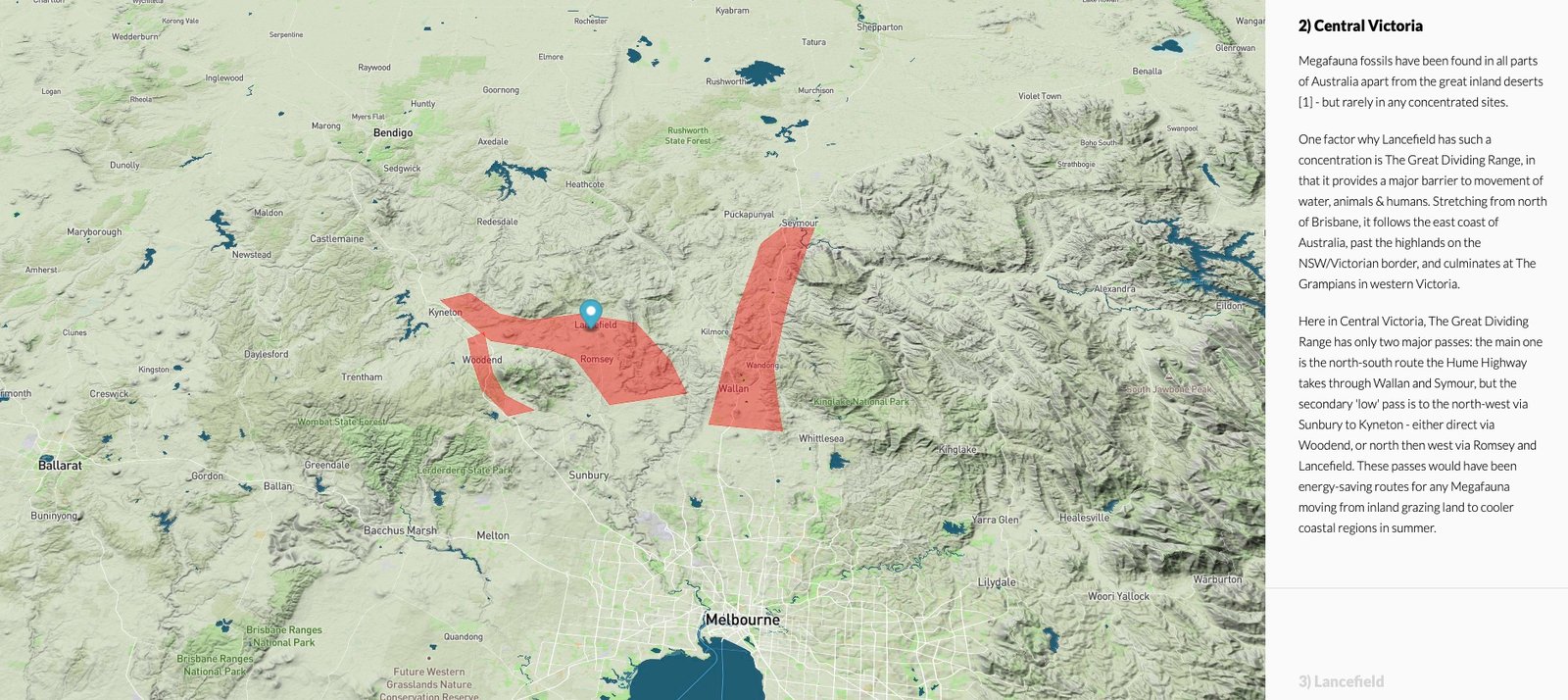
2) Central Victoria
Megafauna fossils have been found in all parts of Australia apart from the great inland deserts [1] - but rarely in any concentrated sites.
One factor why Lancefield has such a concentration is The Great Dividing Range, in that it provides a major barrier to movement of water, animals & humans. Stretching from north of Brisbane, it follows the east coast of Australia, past the highlands on the NSW/Victorian border, and culminates at The Grampians in western Victoria.
Here in Central Victoria, The Great Dividing Range has only two major passes: the main one is the north-south route the Hume Highway takes through Wallan and Symour, but the secondary 'low' pass is to the north-west via Sunbury to Kyneton - either direct via Woodend, or north then west via Romsey and Lancefield. These passes would have been energy-saving routes for any Megafauna moving from inland grazing land to cooler coastal regions in summer.
3) Lancefield
The land around Lancefield is mostly undulating, with a solid line of mountains to the north and west, and the lofty Mount Macedon to the south-west. Also to the south west is Hanging Rock - a picturesque granite outcrop, more famous for its picnics.
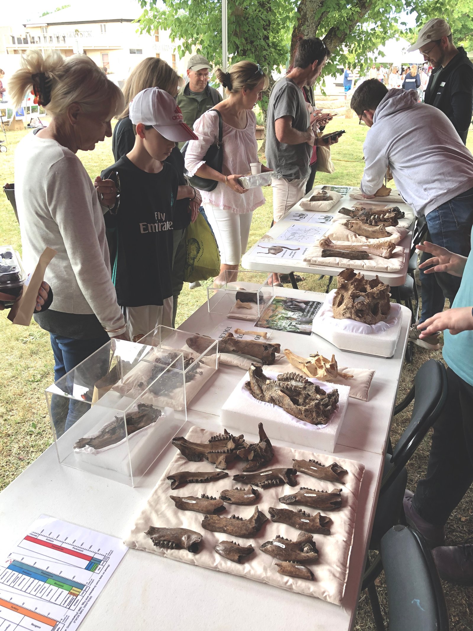
Lancefield is a small country town whose claim to fame is their abundance of fossils found in the area. Each year, they hold a 'Megafauna Festival', with the celebrations split between a big market in the main street, and a dig site on the outskirts of town, where volunteers and academics are on hand to showcase their fossil finds, and to demonstrate how fossil digs work.
4) Dig site
This pond and nearby marsh/bog (marked by the blue pin for the remainder of the story) are situated on the south side of Lancefield, behind the local football oval. To the north, the township slopes downwards towards Deep Creek, but this site been separated from the major waterway over time, leaving behind thousands of fossilised bones: most common are megafauna teeth and jawbones, but some fully intact femurs and skulls have been uncovered.
Sadly. there are no iconic 'Jurassic Park' style intact skeletons waiting to be found here: all the fossils have been found jumbled up, which is associated with being laid down in turbulent water. In contrast, tar pits or dry areas more often result in complete skeletons, and fossils found in slowly running water tend to have their long dimensions aligned with water flow. No predominant fossil directionality has been observed at this site.
5) Lancefield waterways
Zooming out, we see the region to the north in brown as the vast Murray-Darling basin (zoom out to see the full extent) - and the area in blue as the South East Coastal Catchment - ranging from the Vic/SA border, past Sydney and up to the NSW/Qld border.
The rivers and streams around Lancefield all stem from west - from a low saddle near Newham, that sits between the two major catchment areas described above - and then curls east into Lancefield and turns roughly south towards Port Phillip via the Maribyrnong River.
6) The unique 90° bend
The sizeable mountains to the north and east of Lancefield form an impenetrable barrier for water to escape in those directions, instead making the flow turn an abrupt 90°. The outlet to the south is relatively flat and wide, promoting a slowing down of the natural watercourse, which helps to lay down sediment, which obstructs outflow over time.
When water levels are low or normal, this bend is part of a healthy water system, but in mega-floods or potential spillage from the Murray-Darling over into the this region, the whole Lancefield area has the potential to become a whirlpool, fed by an off-centre inlet, with Lancefield at the centre. Peaks such as Melbourne Hill can cause further obstructions in high water situations, focring water back on itself, feeding the sinkhole effect.
7) Elevation analysis
When the elevation is highlighted using hypsometric tinting (a fancy term for colouring similar elevations), our Dig Site (blue marker) reveals itself to be in the middle of a gentle slope, off the main east-then-south run of Deep Creek that traverses the region.
If you zoom out, you can explore the saddle/pass to the west of Lancefield that extends to Kyneton. This pass is certainly a candidate 'Megafauna highway' between the plains of north-west Victoria and Port Philip. As an added bonus, the highway even came with its own water supply - making it an important route for grazing megafauna.

Note: 3D elevation may take some time to load/draw, depending on your computer and/or internet speed.
8) Slope analysis
This image is derived from slope data from Geoscience Australia, painted in one of 8 colours representing the cardinal directions of the compass.

By comparing to the underlying map, we can see the area immediately south-east of Lancefield is either a white or light red colour - indicating that the land generally slopes back to the north-north-west, towards the township. This further supports the possibility of a cauldron/whirlpool effect in the area, given the right conditions. Time to simulate those conditions.
9) Water Flow Simulation
On screen is a Watershed Simulation, that starts with finding high points (the orange dots) as 'seeds' to determine water flows. Each blue region is a distinct water collection zone, with the direction of the flow moving from the dot towards the dark blue centre of the region, and continuing downstream in that general direction.
By comparing the water flow direction with the underlying geography, we can form a picture of strong flows off the mountains to the west, north and east, collecting in Deep Creek to the north of Lancefield. But we also see the area to the south of Lancefield rolling gently north, towards Lancefield, but equally gently south towards the outlet in Melbourne. This reveals the general ambivalence of the 'wash' area south of Lancefield helping to create back-flow - the whirlpool/sink-hole effect, in a clockwise direction, centred around Melbourne Hill.
The most telling piece of the puzzle is the wide 'U' shaped flow region south of Lancefield, circling Melbourne Hill. This area is particularly flat, with any water passing west between Melbourne Hill and Rocky Hill being pushed northward back to Lancefield, via the dig site.
10) Conclusion
While megafauna fossils exist in many parts of Australia, the unique set of circumstances around Lancefield have helped to concentrate the discoveries into one small region:
- The saddle between Sunbury and Kyneton provided an easy passage across the Great Dividing Range from inland grasslands to Port Philip.
- The northern pass around Mount Macedon has an available water supply at all times, with a natural depression at Lancefield allowing for standing water.
- This northern pass has the potential to help feed water from the Murray-Darling Catchment basin over into the Coastal Catchment under high water.
- During high water conditions, the mountains to the north and east of Lancefield cause Deep Creek to take a sharp 90° bend.
- Immediately after this bend, the water is both restricted and potentially turned back towards Lancefield in a wide clockwise whirlpool.
- Already heavily trafficked by megafauna over the past 2.5 million years, any fossils in the region would get caught up in the maelstrom.
- The dig site on the south of Lancefield is a small 'lip' - one last obstruction - before rejoining Deep Creek.
- In the same way gold is captured by the lip of a gold pan in water, so too, megafauna fossils have been deposited in the bog at Lancefield - simply awaiting discovery, clean up, and classification.